Rare genuine WWII British map, Caen, Second Edition (March 1944), Sheet No. 40/16 S.W., scale 1:25,000.
This map covers a large perimeter south-east of Caen, Normandy, France, which was completely liberated on July 19, 1944, following the death of 2,000 of its citizens and the destruction of a great number of public buildings and private properties.
Edited by the General Staff-Geographical Section of the War Office.
Quite good overall condition. Dimensions: 19.5in x 24in.
You might also like
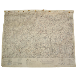
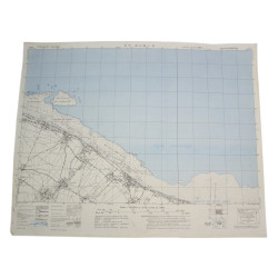
Rare genuine WWII British map, Caen, Second Edition (March 1944), Sheet No. 40/16 S.W., scale 1:25,000.
This map covers a large perimeter south-east of Caen, Normandy, France, which was completely liberated on July 19, 1944, following the death of 2,000 of its citizens and the destruction of a great number of public buildings and private properties.
Edited by the General Staff-Geographical Section of the War Office.
Quite good overall condition. Dimensions: 19.5in x 24in.