Rare genuine WWII British map of Normandy, Carentan, Sheet 31/18 S.E., scale 1:25,000. Edition of June 1943.
The present map covers a large perimeter bounded by the towns of Cretteville, Saint-Côme-du-Mont, Carentan and Le Plessis.
Some of the most iconic battlefields where the 101st Airborne Division fought the Fallschirmjäger-Regiment 6 and the 17. ᛋᛋ-Panzergrenadier Division „Götz von Berlichingen“ from June 6 to 13, 1944 are visible on the present map -- the Dead Man's Corner, Angoville-au-Plain, the Purple Heart Lane, la Billonnerie, Bloody Gulch...
Good overall condition.
Dimensions: 20in x 24.4in.
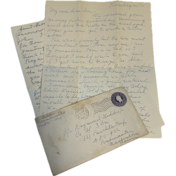
The inscriptions written on the reverse indicate that the present map once belonged to some Rhinehart, Wilbur M., ASN 34500173.
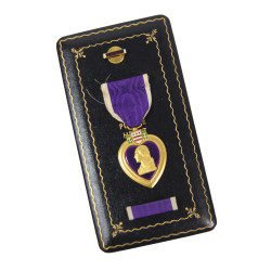
Wilbur Mac Rhinehart was born on July 24, 1920 in Chattanooga, Tennessee and joined the US Army on December 15, 1942. He was soon awarded his 'jump wings' and went on to serve with Headquarters, 3rd Battalion, 501st Parachute Infantry Regiment, 101st Airborne Division, parachuting into Normandy on D-Day, prior to being wounded in action during the fighting for Carentan six days later, hit by a bullet in his right leg. A recipient of the Bronze Star, he was discharged as a Private, and passed away on August 4, 1977.
https://www.afb.org/HelenKellerArchive?a=d&d=A-HK07-01-B035-F12-001.1.1
https://fr.findagrave.com/memorial/2992334/wilbur-mac-rhinehart
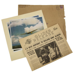
Illustration documents available in digital format only.
You might also like
Rare genuine WWII British map of Normandy, Carentan, Sheet 31/18 S.E., scale 1:25,000. Edition of June 1943.
The present map covers a large perimeter bounded by the towns of Cretteville, Saint-Côme-du-Mont, Carentan and Le Plessis.
Some of the most iconic battlefields where the 101st Airborne Division fought the Fallschirmjäger-Regiment 6 and the 17. ᛋᛋ-Panzergrenadier Division „Götz von Berlichingen“ from June 6 to 13, 1944 are visible on the present map -- the Dead Man's Corner, Angoville-au-Plain, the Purple Heart Lane, la Billonnerie, Bloody Gulch...
Good overall condition.
Dimensions: 20in x 24.4in.
The inscriptions written on the reverse indicate that the present map once belonged to some Rhinehart, Wilbur M., ASN 34500173.
Wilbur Mac Rhinehart was born on July 24, 1920 in Chattanooga, Tennessee and joined the US Army on December 15, 1942. He was soon awarded his 'jump wings' and went on to serve with Headquarters, 3rd Battalion, 501st Parachute Infantry Regiment, 101st Airborne Division, parachuting into Normandy on D-Day, prior to being wounded in action during the fighting for Carentan six days later, hit by a bullet in his right leg. A recipient of the Bronze Star, he was discharged as a Private, and passed away on August 4, 1977.
https://www.afb.org/HelenKellerArchive?a=d&d=A-HK07-01-B035-F12-001.1.1
https://fr.findagrave.com/memorial/2992334/wilbur-mac-rhinehart
Illustration documents available in digital format only.